The British Outflank Coastal Patriots
Location
Other maps: Bing, Google, MapQuest.
Coordinates: 34.7179, -77.9818.
Type: Stop
Tour: Cape Fear
County: Duplin/Pender
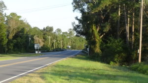
Park on the wide shoulder of NC 117 East by an abandoned access gate, northwest of and facing the bridge over Rockfish Creek. The coordinates are directly across 117 from the western tip of a triangle formed by it, NC 11, and a curved connector road between the two.
You may remain in your vehicle.
Description
The Battlefield
British Maj. James Craig left his base in 1781 Wilmington often to suppress Patriot activity in the region. In August he issued an ultimatum to the free men of the region to take a loyalty oath to the King and join the Loyalist (“Tory”) part-time forces called “militia.” The next day he moved out to arrest men who refused and destroy their properties.
You are looking at Rockfish Creek where the Duplin Road crossed it, a dirt wagon route running a little southwest (right) from where NC 117 does today. Patriot (“Whig”) militia regiments under temporary Brig. Gen. James Kenan and Brig. Gen. Richard Caswell, the former state governor and current state militia commander, took up a position here to resist Craig’s move. Though Caswell outranked Kenan, his regiment arrived later, and this was Kenan’s county. Most pension requests written by veterans years later say Kenan was in command.[1]

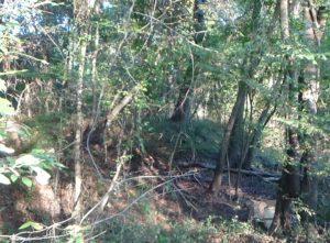
Sources differ as to whether there was a bridge in 1781, or just a ford. This is speculation, but an overgrown double-track dirt lane to the right of the current highway across the creek could be the remains of a ford approach road. The location aligns with a 1907 source saying there was a ford, ends abruptly at the far end, and has a side track that provides a less steep approach appropriate for wagons. The lane is no longer accessible.

The Patriots built a breastwork, a protective earthen ridge. It probably ran from somewhere near the fork of the modern highways ahead of you, down along the creek, to where the stream curves westward (behind you) in the distance. (The 1907 source claimed some remnants still existed at that time.[2]) A few men may line it, but most are in the camp, likely to the right and left of where you are parked.
A few Patriot militia on horseback probably appeared up the road on Thursday, August 2, 1781, at a gallop, yelling that the British had arrived. Some officer had made the mistake of only placing them three miles out, not enough distance to allow sufficient warning of enemy horsemen. Cries of alarm went up, and men rushed to the earthwork and filled in behind them, a total of around 330 men.
Craig’s army appeared in the distance on the road. It was the same size as the Patriots’, but these were regular troops with artillery, and heavily armed cavalry called “dragoons.” The Redcoat infantry marched into range, formed into a line along the road facing the Whigs, and the artillery opened up on the earthworks. The two sides briefly exchanged intense gunfire. But the Patriots broke after a few rounds.
That’s probably because dragoons, under Capt. John Gordon, a Loyalist merchant from Wilmington,[3] charged in from behind you—and them! Craig sent the cavalry to ford the creek roughly a mile west (perhaps where Railroad Street crosses the creek today, since later bridges were often built on fords). Pickets there simply fled rather than coming to warn their comrades. Gordon completely surprised the Patriots from the rear.
All of the Whigs broke into a run north, most probably up the Duplin Road (now NC 11). Kenan and his officers tried to rally them, but it was too late. Gordon’s riders killed 60 Patriots and captured 20 to 30, 27% of the force. One Patriot had his left arm disabled for life by a sword cut. Others deserted for the rest of the war. The little supply of remaining ammunition, along with the rest of their baggage and supplies, was captured as well. The British had few if any men wounded, and none killed or captured.
Gov. Thomas Burke was furious with Kenan about the battle, having ordered all Patriot militia leaders to resist foraging parties and Loyalist raids, but not directly engage Craig’s corps. In a letter he blames the defeat on “‘want of due precaution and imprudence of attempting a stand under the several disadvantages of inferior numbers (which was not true), want of cavalry and uncovered flanks, not to mention the want of discipline.’” He adds, “‘In consequence of this indiscreet officer, the country is now uncovered.’”[4]
Indeed, Craig remained in Duplin County (much larger at that time) for ten days, doubling his force in size by recruiting Loyalists and escaping slaves, and raided as far as New Bern.[5]
Cornwallis Marches By
The larger British army of Lt. Gen. Lord Charles Cornwallis took the same road and crossed here on his march north from Wilmington to Virginia, on April 27 or 28, 1781. He had withdrawn to Wilmington to let his army recover from damage incurred at the Battle of Guilford Court House (now in Greensboro). Had you been here that day, you would have seen around 1,350 Redcoats and German mercenaries, several hundred Tory militia, and an unknown number of camp followers and escaping slaves cross the creek over a period of many hours. It is possible they camped here, probably on the south (far) side, but records are not clear.
Monument
A monument related to the battle is nearby, but has no information on it.
If you want to visit nonetheless:
- Back up if needed, and carefully cross NC 117 to take the connector to NC 11.
- Turn left, and then take the first paved road on the right, Wastetreatment Plant Road.
Note: The state historical marker for the battle is near the corner.
You will see the monument on the left.
More Information
- Barefoot, Daniel. 1998. Touring North Carolina’s Revolutionary War Sites. Winston-Salem, NC: John F. Blair, Publisher.
- Carr, J. O. 1907. “The Battle of Rockfish Creek in Duplin County: The North Carolina Booklet 6:3 (1907).” 1907. http://penelope.uchicago.edu/Thayer/E/Gazetteer/Places/America/United_States/North_Carolina/_Texts/journals/The_North_Carolina_Booklet/6/3/The_Battle_of_Rockfish_Creek*.html.
- De Van Massey, Gregory, ‘The British Expedition to Wilmington, North Carolina, January-November, 1781’ (East Carolina University, 1987)
- Dunkerly, Robert M., Redcoats on the Cape Fear: The Revolutionary War in Southeastern North Carolina, Revised (Jefferson, N.C.: McFarland & Company, Inc., Publishers, 2012)
- Lewis, J. D. 2012. “Rockfish Creek.” The American Revolution in North Carolina. 2012. https://www.carolana.com/NC/Revolution/revolution_rockfish_creek.html.
- “Marker: F-7.” n.d. North Carolina Highway Historical Marker Program. Accessed January 29, 2020. http://www.ncmarkers.com/Markers.aspx?MarkerId=F-7.
- McEachern, Leora, and Ruth Walker. 1981. “Pensioners Remember the War.” Lower Cape Fear Historical Society Inc. Bulletin, January 1981. https://www.lcfhs.org/uploads/1/1/9/8/119823026/bulletin_jan_1981.pdf.
- Tetterton, Beverly. 2006. “Rockfish, Battle Of.” NCpedia. 2006. https://www.ncpedia.org/rockfish-battle.
[1] Lewis 2012.
[2] Carr 1907.
[3] Dunkerly 2012.
[4] Ibid.
[5] Ibid.
← Moore’s Creek | Cape Fear Tour | Beaufort Raid →


