
Location
Other maps: Bing, Google, MapQuest.
Coordinates: 36.2009, -79.9033.
Type: Sight
Tour: Guilford Battle
County: Guilford
![]() Full
Full
Odyssey Dental of Summerfield has kindly allowed AmRevNC users to park in their lot.[1] At busy times, please park toward the back. If it is full, return to Summerfield Road, turn left, and park in the Sheriff’s Office lot (the next driveway on the left); a sidewalk leads back past the dental office.
All stops are visible from pavement or within your vehicle.

Context
 The Continental army of the South has been withdrawing from the Charlotte region before its British counterpart, while trying to gather enough militia to take a stand, in a campaign now called “The Race to the Dan.”
Situation
Continental
Maj. Gen. Nathanael Greene has camped on the heights around the Guilford County Courthouse, now in the town named for him, Greensboro. He formed a “light corps” of cavalry and fast-moving infantry under Col. Otho Williams to guard against, and keep an eye on, the British. Williams has moved in this direction (northwest) to look for the Redcoats, probably sending forward small patrols.
British
The British army under Lt. Gen. Lord Charles Cornwallis is trying to hunt down the Americans. It zig-zagged east from modern Winston-Salem and is marching in this direction, the front perhaps as close as a mill a few miles west (across NC 68, which runs by the Greensboro airport to Oak Ridge, from a later mill there today).
Date
Sunday, February 11, 1781.
Timeline

Imagine the Scene
Breakfast is Interrupted
Most of the details of this story come from two eyewitnesses, secondhand in one case. The earliest known sources are three books published at least 47 years later, which differ on many points. Veteran’s pension applications confirm the basic facts, but believe details with caution.
Walk to the front of the fenced-in area by the driveway.
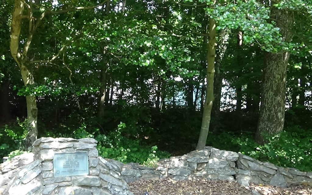
You are on the plantation of Charles Bruce, along with his family and an unknown number of enslaved people. The home itself was on the hill behind and to the left of the graveyard[2], hidden by leaves during warmer months. A veteran reported years later this is a muster point for local part-time “militia” soldiers, both for the 1776 campaign against the Cherokees in the far west of the state, and one to suppress Loyalists in the Cross Creek (Fayetteville) area the next year.[3] Two major wagon roads meet a half-mile north (right if facing the road) at “Bruce’s Crossroads,” the current intersection of Summerfield and Oak Ridge roads.
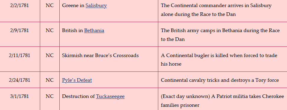
The Bruce family cemetery is inside the fence. Look at the tombstone, which is probably not by his actual grave.
Charles Bruce was born in Virginia to a large landowner, who died when Charles was an infant. Little is known about Bruce’s life until he married in Oxford, N.C., in 1768 and moved to Guilford County the next year. He was elected to the 1776 Provincial Congress in Halifax that declared support for independence. The next year he was appointed by the state to recruit Continental troops in the county, and as a commissioner to oversee completion of the “Courthouse, Prison, and Stocks” around which Greene’s main army now is camped.
In September 1780, a civil war between Patriots and Loyalists was heating up, thanks to the British being in South Carolina. A letter from the N.C. Board of War to a militia colonel says, “Mr. Charles Bruce has in his possession a large Quantity of Money, and is now on his way to Little River and Duplin County. He has applied to me for a Guard, thinking it dangerous to go without…” The author does not say what the money is for, but orders the colonel to provide protection! Near the end of the war two years later, Bruce was appointed as a public auditor. That same year he may have built a mill on Robeson Creek, which runs behind the modern school across the road.[4] Afterwards he was named a commissioner for the sale of property confiscated from Loyalists, and like many of those men, managed to buy some of it at low prices.[5]
Turn around to face the road.
Around noon on Sunday, February 11, 1781, Williams’ light corps of 700 cavalry and infantry flows up the wagon road where Summerfield Road is now from the left, and probably past you onto the grounds of Bruce’s Plantation.[6] Included is the “American Legion” cavalry of Lt. Col. “Light Horse” Henry Lee. Neither men nor horses having eaten that morning, the troopers make fires and begin cooking breakfast. A spring on the property may have provided water.[7] Lee says in his memoir, “The morning was cold and drizzly; our fires, which had been slow in kindling, were now lively; the meat was on the coals; and the corn cake in the ashes.”[8] The rains have made their gunpowder damp, cavalry trooper James Martin told people years later.[9] That means their guns may be unreliable, but reports from their scouts indicate the British are nowhere near.
A local farmer, Isaac Wright, rides in on a puny farm horse, probably down the road from the right, and asks to speak to the commander. He tells Williams he spotted the British four miles away. According to Martin, Lee does not believe Wright and insults him, but Martin intervenes.[10] Lee orders Capt. James Armstrong and a few men to investigate with Wright, and they move out to the right toward Bruce’s Crossroads.[11]
A message apparently arrives from a patrol, however, confirming the British are close. Williams decides Armstrong should have more men, and sends Lee to join him with a detachment of 18-30 troopers (sources differ). First Lee orders someone ahead to tell Armstrong to slow down, and Lee’s group catches up after a mile or so.
With them is Lee’s bugler, James Gillies. Contrary to modern claims, including an historical marker seen later, the only early source that mentions his age says he was around 18.[12] Lee merely describes him as a “beardless boy.” The minimum age for soldiers was 16. However, one historian compiled 600 stories of boys and a few girls who disguised themselves to enlist, most at 14 or 15, so it is possible he was younger.[a]
Gillies is buried in the Bruce family cemetery. Read the first “Historical Tidbit” below for details.
If you wish, visit the 1923 Daughters of the American Revolution (DAR) monument across the street to Gillies and Bruce.
Surprise and an Attack
To learn how Gillies died, go back to your car and follow the troopers:
- Turn right on Summerfield Road.
- Drive 0.5 miles to Oak Ridge Road (NC 150), and turn left.
Note: This intersection was Bruce’s Crossroads. - Drive 1.8 miles and turn left into the farm lane just before the “Welcome to Oak Ridge” sign.
Note: Please avoid the private driveway just before the lane. - Pull to the right out of the lane and park facing the sign, where you can see down the road.
You are within the public right-of-way, and can stay in your vehicle.
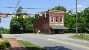
The narrow, dirt wagon road of the day takes a straighter path than the modern curve you just followed, and probably returns to the route followed by Oak Ridge Road about here. Forest crowds both sides at the time. Lee and the Continentals, all wearing green coats, ride through your vehicle. Likely within your view down the road, however, Lee pulls up. He has begun to question Wright’s information. Wright points out he was scared and may be wrong on the distance. Lee says he is going back, but sends Armstrong on with three dragoons and Wright.
But Wright—perhaps noticing that the cavalrymen around him on their fine steeds look nervous—refuses to go on riding his farm horse. So Lee orders Gillies to loan his mount to Wright. Perhaps you see them make the exchange in the distance. Here sources differ on the direction Gillies takes. Lee claims he ordered Gillies to take Wright’s horse back to camp and update Williams. Other sources, based on stories from one of the troopers, suggest Gillies was afraid Wright would ride off with his horse, so he hops on Wright’s horse and trails after them.
Armstrong’s group probably disappears around the slight curve in the distance and then a sharper bend beyond it. Lee and the rest of the detachment take to the woods within sight of the road to ride back, as a precaution in case the British are indeed close.
They are.
Suddenly you hear a round of gunshots in the direction Armstrong took. Then you hear pounding hoofbeats. Wright and the men appear at a full gallop. Quickly you see why: According to one source, British dragoons (heavily armed cavalry) had been resting by the road past a bend. The curve and woods of the time would explain why the Americans had not seen them sooner, and the sharper turn mentioned above aligns with what happens next. Regardless of exactly where the two sides surprised each other, the British now are mounted and close behind, also wearing green coats. Both groups pass Lee in the woods heading toward you. Lee says he waited to make sure the British were cut off from their support behind them. Armstrong’s men ride through or around you.
Between the two parties on the road is Gillies. The farm horse is lagging behind. Lee wrote years later, “’This ill-fated boy was one of the band of music, and exclusively devoted in the field to his bugle, used in conveying orders. Too small to wield a sword, he was armed only with one pistol, as was the custom of the Legion; that sort of weapon being considered of little import in action; now he had not even his pistol, it being with the countryman mounted on his horse.’”[13]
The Bugler Falls
Back your vehicle around, and follow Gillies back the way you came:
- Turn right from the lane, heading towards the crossroads.
- Drive only one-tenth of a mile and turn right into the utility driveway.
Note: You will pass a town historical marker just before it. - Immediately pull off to the right and park.
Walk to the DAR monument using the paved trail. Continue to the right end of the wall, and look back into the woods.
Here the 1781 road runs through what now is the utility substation visible on the other side of the trees, supposedly about where the closest building is within the fenced area. The road passes through a stand of oak trees, according to one of the early writers, Rev. E.W. Caruthers.
Gillies and the British come down the road from right to left. Some of the British surround Gillies and pull him off his horse. They draw their sabres and run him through as he begs to surrender, according to Lee.
The exact site where this happened is lost, but local tradition 100 years later held it was at the base of a tree still standing at the time. A 1920s professor said the spot was marked around then with the small cube the monument now curves around—the “G” on top stands for “Gillies.” He adds it was moved to this location to be closer to the newly paved road where NC 150 now runs, rerouted to get around the gully in front of you.[14] Perhaps the cube was directly downhill by the old road.
Regardless, Lee and his men, enraged, emerge back onto the road and charge from the right. The British scramble into a formation to meet them. At least seven of the British are killed immediately and fall to the road and ground, probably between the utility station and the sign you were at before.
A Continental volunteer, Peter Johnson, is among the troopers. Johnson engages in a sword duel with a British dragoon. His opponent’s foot gets under his and throws him off balance. He sees the English sabre raised and headed toward him when something wet splashes across his cheek. A wipe of the hand reveals blood and brains—but not, as he first feared, his own! A comrade of Johnson had seen his plight and arrived just in time to split the man’s upper ear and head nearly off.[15]
The rest of the British unit, under a Cornet Miller,[16] tries to escape back up the road. Patriot Lt. Stephen Lewis gives chase with some other men. Lee, furious at what happened to Gillies, yells after them to give no quarter—meaning to kill, not capture.
Lee directs one of his larger men to pick up Gillies’ body, and another to accompany them back to the Bruces’. He then takes the rest of the men after Lewis. Shortly they come upon him returning with Miller and most of the British: The lieutenant ignored Lee’s order. (Lee himself admits in his memoir it went against usual Continental standards.) Lee says Miller was not injured, “but his dragoons were severely cut in the face, neck, and shoulders.”
Lee gives Lewis a dressing down, and tells Miller to prepare to die. The group moves off toward the plantation.
As they ride, Miller claims he was only scouting and tried to stop his men, but they were drunk. Lee says he was almost persuaded, but near the start of a long downhill, they catch up to Gillies’ escort. (Most likely this is the slope which starts around the next road on the right in that direction, Birkhaven Drive, and drops all the way to modern I-73.) As they continue down the hill, he decides he will hang Miller in a small valley ahead. He pulls out some paper and a pencil, and hands them to Miller. Lee tells the cornet to write a final note to his friends, which he promises to pass to the British.
Fate is fickle, however. A pistol shot from men monitoring the British in the rear tells them the “van” or front of the British army is near. Lee, no doubt frustrated by the turn of events, orders his men on to the plantation with their prisoners. From there Williams sends the latter on to Greene, and Miller escapes his doom.
Gillies is left in some woods, because they cannot risk the time to bury him. The Continentals withdraw.
After the Skirmish
The van of the British, around 800 men under Brig. Gen. Charles O’Hara, marches past you. Lee says it is not until the next day, as the main army catches up, that the casualties scattered in this area are buried. (He doesn’t say how he knows that.)
O’Hara camps at Bruce’s Plantation. Bruce had gone off with Lee after sending his wife Elizabeth and children to his father’s house, in the care of an enslaved servant, Jack. Caruthers says of the British, “They took all the provisions, grain, and forage they could find, burned the fences with all the out-buildings and were about to apply the torch to the dwelling-house…” Two Quaker neighbors intervened to stop them. Some of this was witnessed by Jack, who supposedly volunteered to check on the property and report back to Elizabeth.
Bruce apparently returned soon after, because years later he told the visiting Johnson that he had buried Gillies personally. See the “Historical Tidbits” for more.
Battle Map
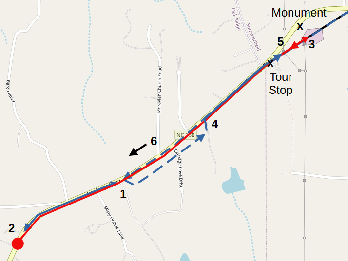
Bruce’s Crossroads: Eastern locations are approximate; western are guesses. 1) Continental patrol moves west (left); Lee turns back into woods. 2) Patrol, British surprise each other; British give chase. 3) Gillies caught, killed. 4) Lee returns to road, charges. 5) British turn, skirmish with Lee. 6) Somewhere to the west, troopers capture the British.
Casualties
- British: 14–20 killed, unknown wounded, 4–8 captured.
- Continental: 1 killed, unknown wounded.
Historical Tidbits
- The Summerfield Historical Committee investigated the Bruce cemetery with ground-penetrating radar (GPR). They found a pair of small graves on either side of the tree on the left; a large one between the trees on the back side, its far end in line with the trees; and a slightly smaller one next to it, just this side of the tree on the right. Records show the Bruces lost two infants at childbirth, and that the Bruces are buried here. There is also one large separate grave just to the right of the Bruce marker (by coincidence), running back into the cemetery, its near end almost aligned with the marker. The committee’s guess is this last grave is that of Gillies. (See the first picture on the page.)[17]
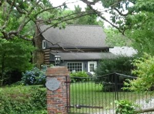
- In 1826 Johnson, by then a judge, revisited the area from his home in Abingdon, Va., by way of Richmond. His carriage overturned and broke a horse shaft, leaving him badly bruised. A wagonmaker’s shop was nearby, which sent him to Rev. Henry Tatum’s house to wait. Johnson recognized this as being near the site of these events. He told the story to a group by the fire. Tatum’s wife was Bruce’s daughter. Betsy said her father had told the story many times, and called Bruce to the house, where the two men reunited.[18] As Johnson left, he asked what he owed. Tatum supposedly said, “Sir, a word on the subject would cruelly wound my feelings, your account was settled in the year 1781. Your conduct was a receipt in full.”[19] Though it is altered, the Tatum’s log cabin still exists. To see it, from the monument, turn right. Drive 0.25 miles to the second left, Whitaker Drive. Turn left, and after a short distance, turn left again onto Penns Grove Road. Drive 0.2 miles, and the house is at 7622 on the right. A fireplace in the original section has bricks bearing the date “1807” above the initials “HT” and “BT.” (This is private property, not open to the public; please respect the owners’ privacy.)


More Information
- ‘Acts of the North Carolina General Assembly, 1782, Volume 24, Pages 413-474’, Documenting the American South: Colonial and State Records of North Carolina <https://docsouth.unc.edu/csr/index.php/document/csr24-0012> [accessed 14 May 2021]
- ‘Acts of the North Carolina General Assembly, April 07, 1777 – May 09, 1777, Volume 24, Pages 1-42.’, Documenting the American South: Colonial and State Records of North Carolina <https://docsouth.unc.edu/csr/index.php/document/csr24-0001> [accessed 14 May 2021]
- ‘Acts of the North Carolina General Assembly, October 1784, Volume 24, Pages 650-709’, Documenting the American South: Colonial and State Records of North Carolina <https://docsouth.unc.edu/csr/index.php/document/csr24-0015> [accessed 14 May 2021]
- Barefoot, Daniel, ‘Bruce’s Cross Roads, Battle Of’, NCpedia, 2006 <https://www.ncpedia.org/bruces-cross-roads-battle> [accessed 28 April 2021]
- ‘Bugler Boy Historic Site’, Town of Summerfield, NC <https://www.summerfieldnc.gov/index.asp?SEC=C3FB91F1-C656-4336-B855-D9948EAC060A&DE=EE3B01BF-20EB-46B8-8780-EA7E40D04899> [accessed 25 May 2021]
- Caruthers, E. W. (Eli Washington), A Sketch of the Life and Character of the Rev. David Caldwell, D. D. (Greensborough, N.C. : Printed by Swaim and Sherwood, 1842) <http://archive.org/details/sketchoflifecharact00caru> [accessed 23 April 2020]
- Caruthers, E. W. (Eli Washington), Interesting Revolutionary Incidents and Sketches of Character, Chiefly in the ‘Old North State.’ (Philadelphia : Hayes & Zell, 1856) <http://archive.org/details/interestingrevol00incaru> [accessed 23 April 2020]
- ‘Charles Bruce (1740-1832) – Find A Grave Memorial’ <https://www.findagrave.com/memorial/41856333/charles-bruce> [accessed 11 May 2021]
- ‘Charles Bruce and Lorena V. (Name Obscured)’, Undated, Quaker Archives, Guilford College, Fred Hughes Papers, Box #2, ‘Guilford: Photocopies from Various Imprints’
- ‘Col. James Martin’, Western Carolinian (Salisbury, N.C.), 1834/11/15, 1834, 3
- Cook, Sam, Gillies, E-mails, 2021
- Cook, Sam, ‘Local Fallen Hero: James Gillies’, 2007
- Crowder, Jack, Underage Warriors (Heritage Books, Inc., 2017)
- Donnell, Dore Korner, ‘Bugler Boy’s Story… Marker in Memory of Young Gillies Will Be Unveiled by D.A.R. Tuesday’, Newspaper article, publication unknown, 20 September 1941
- Garden, Alexander, Anecdotes of the American Revolution (Charleston, [S.C.] Printed by A. E. Miller, 1828) <http://archive.org/details/anecdotesofameri00gard> [accessed 7 May 2021]
- ‘Geni – Senator Charles Bruce, I (1740-1832)- Summerfield’ <https://www.geni.com/people/Charles-Bruce-1/6000000001749570940#/tab/overview> [accessed 11 May 2021]
- Guilford County: A Map Supplement (Jamestown, NC: The Custom House, 1988)
- Harris, C. Leon, tran., ‘Pension Application of John Hewitt W2618’, Southern Campaigns Revolutionary War Pension Applications & Rosters <https://www.revwarapps.org/> [accessed 5 May 2021]
- ‘Historical Documentation Map, Guilford County, N.C.’ (Jamestown, NC: Custom House, 1980)
- Hoskins, Katherine, ‘Bugler Gillies, Victim of War’, Greensboro Daily News (Greensboro, NC, 1 July 1931a)
- Hoskins, Katherine, ‘Charles Bruce: A Friend of Liberty’, Greensboro Daily News (Greensboro, NC, 1 July 1931b)
- Hoskins, Katherine, ‘Sketch of Charles Bruce of Guilford’, Greensboro Patriot (and Typewritten Draft) (Greensboro, NC, 1 June 1922), Greensboro Public Library, North Carolina Collection
- Hoskins, Katherine, ‘Typewritten Page, “Bruce, Charles” Biographical File’, (Ca. 1920s), Greensboro Public Library
- Lee, Henry, Memoirs of the War in the Southern Department of the United States, 2nd edition (P. Force, 1827)
- Lewis, J.D., ‘Summerfield’, The American Revolution in North Carolina, 2009 <https://www.carolana.com/NC/Revolution/revolution_summerfield.html> [accessed 28 April 2021]
- MacLeod, Mrs. John Blount, et al., Seventy-Five Years of Service: History of the National Society Daughters of American Revolution of North Carolina (New Bern, NC: Owen G. Dunn Co., 1975)
- ‘Minutes of the North Carolina Board of War, September 14, 1780 – January 30, 1781. Volume 14, Pages 376-495.’, Documenting the American South: Colonial and State Records of North Carolina <https://docsouth.unc.edu/csr/index.php/document/csr14-0396> [accessed 14 May 2021]
- ‘Minutes of the North Carolina Council of State, September 02, 1777, Volume 22, Pages 926-929’, Documenting the American South: Colonial and State Records of North Carolina <https://docsouth.unc.edu/csr/index.php/document/csr22-0663> [accessed 14 May 2021]
- ‘Minutes of the Provincial Congress of North Carolina, April 04, 1776 – May 14, 1776’, Documenting the American South: Colonial and State Records of North Carolina <https://docsouth.unc.edu/csr/index.php/document/csr10-0250> [accessed 14 May 2021]
- ‘Obituary’, The Western Weekly Review (Franklin, TN, 30 March 1832)
- Peterson, Bruce, ‘The Importance of a Small Skirmish during the Race to the Dan’, Journal of the American Revolution, 2021a <https://allthingsliberty.com/2021/09/the-importance-of-a-small-skirmish-during-the-race-to-the-dan/> [accessed 24 September 2021]
- Petersen, Bruce, Follow-up on Gillies, E-mails, 2021b
- Poquet, Nancy, tran., ‘Pension Application of Samuel Rayl #S4034’, Southern Campaigns Revolutionary War Pension Applications & Rosters <https://www.revwarapps.org/> [accessed 5 May 2021]
- Sherman, Wm. Thomas, Calendar and Record of the Revolutionary War in the South: 1780-1781, Tenth Edition (Seattle, WA: Gun Jones Publishing, 2007) <https://www.americanrevolution.org/calendar_south_10_ed_update_2017.pdf>
- von Stambach Bruce, Michael, ed., Bruce: The First 1,200 Years (Atlanta, Ga.: The Bruce Family Historical Society, The Royal Bruce Society, 1990)
- Whitaker, T.E., ‘Gillis the Bugler Boy (“Gillies” Biographical File, Greensboro Public Library)’, Newspaper article, publication and date unknown; ca. 1920s.
[1] In-person interview with “Joy,” 5/26/2021.
[2] At the end of Tannery Drive, which is visible from the back end of the parking lot, now private property not accessible to the public (Hoskins 1922 and “Typewritten Page”; Petersen 2021b).
[3] “Pension Application of Samuel Rayl.”
[4] Historical Documentation Map 1980.
[5] Bruce details: Entries from Documenting the American South: Colonial and State Records of North Carolina.
[6] Sources differ on the dates. But local historian Bruce Petersen presents compelling evidence it was the 11th, based on dispatches from Williams to Nathanael Greene on the 11th that almost certainly relate to these events, and troop movements that only seem feasible if it were on the 11th (Petersen 2021a).
[7] Petersen 2021b.
[8] Lee 1827.
[9] “Col. James Martin” 1834.
[10] Ibid.
[11] Caruthers 1842.
[12] Caruthers 1856. The earliest telling of the incident, in Garden (1828) based on Johnson, only says Gillies was “a gallant youth, yet in early life.” The next mention of his age after Caruthers appears to be a newspaper article from the 1920s that says he was 15, without citing evidence (Whitaker, ca. 1920s); twenty years later the age has dropped another year in articles on the DAR monument to him, again without evidence (e.g., Donnell 1941). No early sources mention his parents or state, either; AmRevNC could find no evidence for claims some modern sources make about those.
[13] Lee.
[14] The cube was probably placed on the original road by cadets of what now is called Oak Ridge Military Academy (ORMA). Unfortunately, ORMA archives were destroyed in a fire (Cook 2021). An ORMA professor who investigated the site starting in 1920 wrote that it is identical to a set of 200 given to a judge leading the effort to preserve the Guilford Courthouse battlefield (Whitaker, MacLeod 1975). He added that the original road ran 200 feet south of what then was a new road, which was where NC 150 runs today, according to a 1920 soil survey map. The distance places the old road at the utility building. He also relayed the claim about the oak tree. An ORMA graduate and local historian said the cube was moved in 1913 (Cook 2007). In 1939, a local man named Holt placed a granite marker still visible across the road back toward the Oak Ridge sign, mistaking the cube’s new location for the original death site.
[15] Caruthers 1842.
[16] Most sources reference a “Captain” Miller, but Sherman (2007) says the only Miller of that rank in Cornwallis’ army was in the infantry. Sherman speculates, based on rosters, that the cavalryman captured here was Cornet William Miller.
[17] Petersen 2021b.
[18] Garden 1828. Caruthers (1842 and 1856) corroborated this story, speaking to Tatum and his wife years later, who repeated it to him.
[19] Garden.
[a] Crowder 2017.
← Guilford Court House | Guilford Battle Tour | Whitesell’s Mill →