Greene Escapes Yet Again
Location
Other maps: Bing, Google, MapQuest.
Coordinates: 35.7234, -80.3903.
Type: Stop
Tour: Race to the Dan
County: Davidson/Rowan
The Trading Ford is surrounded by private or railroad property, preventing direct access to it and the sites of events described on this page. Otherwise this would be one of our more detailed “Sight” pages, given the importance of what happened here.
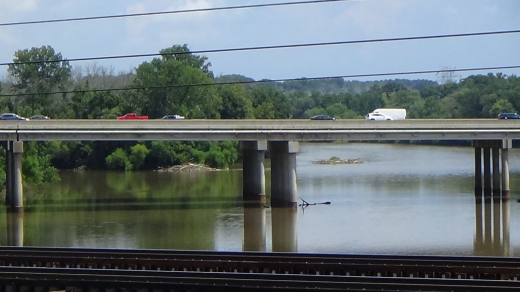
A decent though distant view of the island in the middle of the ford is available from the paved pedestrian path over the US 29/70 bridge. The coordinates take you to a parking area of the adjacent Yadkin River Park.
Description
Early History
Walk onto the bridge and down to the second covered bench. Look to your left at the island on the far side of the I-85 bridge.
What earlier was called “Island Ford,” for obvious reasons, was a relatively shallow part of the Yadkin River on either side of the island you see. The ford was part of a major Native American “Trading Path,” and artifacts indicate people lived here 10,000 years ago. Later wagon roads were built to it from Salisbury toward points east and north.

A Spanish exploration from a colony at modern Parris Island, S.C., led by Capt. Juan Pardo, built Fort Santiago downriver from the island with the help of Guatari Native Americans in early 1568. This was 17 years before the first English settlement in N.C., on Roanoke Island. The Spaniards were soon driven out or killed, and the site is underwater now.
Like the Spaniards, Englishman John Lawson walked here from the coast in 1701. He was making an exploration of the Carolina colony, mostly on foot, in an arc from Charleston to Washington, N.C. He had followed the Trading Path along the route now covered by US 29/70 further south, and arrived on Wednesday, January 29. He stayed with Sapona in their village on the north (left) bank on the far side of the island, for several days. He wrote, “This most pleasant River may be something broader than the Thames at Kingston, keeping a continual pleasant warbling Noise, with its reverberating on the bright Marble Rocks… One side of the River is hemm’d in with mountainy Ground, the other side proving as rich a Soil to the Eye of a knowing Person with us, as any this Western World can afford.”[1]
He notes that the Sapona “king” was holding five prisoners for an unpleasant fate: “The Fire of Pitch-Pine being got ready, and a Feast appointed… the Sufferer has his Body stuck thick with Light-Wood-Splinters, which are lighted like so many Candles, the tortur’d Person dancing round a great Fire, till his Strength fails, and disables him…”
Racers Arrive
In early 1781, Brig. Gen. Daniel Morgan’s Continental Army corps had defeated a British wing at the Battle of Cowpens (S.C.), capturing hundreds of prisoners it was now marching north. A British army under Lt. Gen. Lord Charles Cornwallis was racing to trap Morgan against this river. The Americans had camped at Salisbury and then moved out to try to cross the Trading Ford ahead of Cornwallis’ arrival. This was part of the campaign later named the “Race to the Dan.”
The prior autumn, Continental commander Maj. Gen. Nathanael Greene had ordered Gen. Edward Stevens of the Virginia militia “‘to explore carefully the (Yadkin) river, the Depth of the Water, the Current, & the Rocks, & every other Obstruction that will impede the Business of Transportation…'”[2] That foresight paid off this night, Saturday, February 3. The river was high and the current strong after days of rain that plagued both armies. But the Patriots were ready. From here you might have caught glimpses of small boats crossing back and forth across the river by the far end of the island—rowboats, flat-bottomed “bateaux,” even canoes. It’s unclear where these boats came from. Morgan’s commander, Greene, had discussed the possibility of carrying some on wagons. Some sources believe Morgan had done that [3], and that Greene arranged for others to be gathered while still in his main army camp in S.C. days before.[4] If so, he helped himself personally, because Greene was here that night!
The corps of around 800 part-time soldiers called “militia” and regular Continental troops, plus the prisoners, were hurrying in fear of the British cavalry. It took hours, but they succeeded, and the boats were tied up on the left side of the river. The Americans camped on the heights above.
The British had tried but failed to cut off Morgan at the crossroads that now is Mooresville, and then chased him through Salisbury. By dark they arrived roughly four miles east of Salisbury and 15 miles from the ford, the best over the Yadkin in this region. Cornwallis sent a portion forward to try to catch the Continentals, while the rest of his army set up camp.
Among the distant trees on the right side of the river, perhaps a half-mile past modern I-85, a large number of civilian refugees failed to make it. Around midnight, Brig. Gen. Charles O’Hara’s Redcoats arrived to find 100 Virginia militiamen and 50 cavalry apparently guarding refugee wagons stuck in river mud.

Instead, it was an ambush. Greene’s medical chief, Dr. William Read, wrote that after crossing and visiting the camp, he came back to the riverbank. (It’s unclear how soon afterward he wrote up these events, so believe quotations with caution.) Some officers were there watching the approach of the British “column after column” as the light faded. Morgan approached and said, “‘I have laid an ambuscade of 120 Virginia men for the British; we hope to do them some harm.”[5]
According to Patriot militia Col. Joseph Graham, “The militia were drawn up near a half mile from the ford, where a branch crosses which was covered with small timber and bushes, and there was an old field along the road in their front… The American position was low along the branch, under shade of the timber; that of the advancing foe was open and on higher ground, and between them and the sky, was quite visible.” With the British “within sixty steps,” the Patriots opened fire, which the British returned.[6]
As the firing broke out, Read quotes Morgan to say, “’There are my rifles; there the British pistol.’” Dogs added to the noise.[7]
Graham says the Redcoats formed a line and extended to the right, until they began to turn back the militia on the end of the American line. After firing two or three rounds, the militia easily retreated into the night toward another ford. Looking across the river near this end of the island, however, Read saw a gunshot and the dark shape of a man falling off a horse.[8]
Graham continues, “They passed down the river two miles and crossed over, abandoning the baggage and other wagons which could not be gotten over, to the enemy, after taking out the horses.” The British went on to the Trading Ford but “found the water was too deep to ford, and still rising, and that General Morgan, encamped on the other side, had with him all the boats and canoes.”[9]
The British captured the wagons, adding to the refugees’ misery. The Redcoats lost 10–12 killed or wounded, but none were captured. Two of the militia were killed, an unknown number wounded, and 10 captured.
The next morning, Read, Morgan, and the officers were back at the riverbank trying to see what happened. Some of the Virginians, wet and fatigued, appeared on their side of the river walking in your direction from beyond the island. Read told them what he saw. A young soldier stepped forward to say he fired the shot. “‘I was pursued by a dragoon (while) running across that field; he overtook me, and I wheeled about and shot him; I think he fell. At the moment he gave my rifle a heavy cut,’” which he showed to Read.
Two men volunteered to check on the British. They rode their horses down the sharp bank on the left and across the near end of the island to the right side. On returning they said they saw the Redcoats burying the dead in large pits.[10]
The rest of the British army arrived, now totaling 2,000 men. But Cornwallis realized he has been foiled not only by the Continentals, but by nature. The floodwaters made the ford completely impassable.
Greene Ignores Cannon Fire
Return to your car and:
- Take the parking exit leading downhill, away from the highway, onto Trading Ford Way.
- At the first intersection, Sowers Road, turn right.
Note: There is no information there, but if you want to visit a monument about these events, go straight across. It is on the right after a short distance. Then come back and turn left. - At the frontage road, Wil-Cox Way, turn left.
- Take the first right, NC 150 East, toward the highway.
- Continue straight across the interchange, as the road becomes Seven Oaks Drive, and all the way to the no-trespassing signs near a barely visible railroad yard.
- Park in the turnaround on the left.
Stay within the road, which is a public street up to this point, or the turnaround. You may get a visit from railroad security if you get too close to the no-trespassing signs!
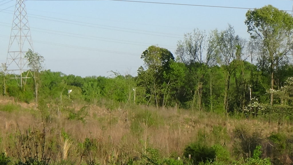
Look at the distant, forested high ground the road appears to point to.
You are likely standing in or near Morgan’s campsite, looking at Gowrie’s Heights across the river. Right after arriving, Dr. Read walked into the camp to check on Morgan. He found him in his tent, “‘very sick, rheumatic from head to feet.’” He advised the general to leave camp for someplace warm and safe. Morgan supposedly replied, “’‘I do not know where that is to be found until I reach Virginia.’”[11]
The British mounted cannons on the heights, and fired a few rounds. Read reports: “‘At a little distance from the river was a small cabin in which General Greene had taken up his quarters. At this the enemy directed their fire, and the balls rebounded from the rocks in the rear of it. But little of the roof was visible to the enemy. The General was preparing his orders for the army and his dispatches to the Congress. In a short time the balls began to strike the roof, and the clapboards were flying in all directions. But the General’s pen never stopped, only when a new visitor arrived, or some officer for orders; and then the answer was given with calmness and precision, and Greene resumed his pen.”[12] Meanwhile, another source says, Catawbas with the Patriots took potshots at the British.[13]

The 1871 book in which the Read quote appears adds that Greene’s “cabin stood about two hundred yards east of Holtsburg depot, and a rod or two to the north of the county road, at the foot of the hill.” The road you are on led to the depot, located where the tracks still run today. So the cabin was the distance of two American football fields to the left along this side of the tracks, under the lip of the terrace ahead of you (probably at a railroad equipment parking area visible on satellite maps).
The next day the Continentals moved off to a safer location south of modern Winston-Salem. Cornwallis reluctantly withdrew his forces to Salisbury to await the river’s drop. But the day after that, he gave up and marched roughly 30 miles upriver to cross at Shallow Ford near modern Huntsville.

More Information
- Barefoot, Daniel, Touring North Carolina’s Revolutionary War Sites (Winston-Salem, NC: John F. Blair, Publisher, 1998)
- Bingham, William, ‘Trading Ford’, NCpedia, 2006 <https://www.ncpedia.org/trading-ford> [accessed 9 February 2020]
- Brownlee, Ann, Trading Ford Sites, Phone Interview, 9/2/2020
- ‘Excerpt from John Lawson Journal – Trading Ford Area’, Trading Ford Historic District Preservation Association <http://www.trading-ford.org/lawson/lawson.html> [accessed 10 February 2020]
- ‘Fateful Day at the Trading Ford’, Trading Ford Historic District Preservation Association <http://www.trading-ford.org/fateful.html> [accessed 9 February 2020]
- Graham, William A. (William Alexander), General Joseph Graham and His Papers on North Carolina Revolutionary History (Raleigh, N.C.: Edwards & Broughton, 1904) <http://archive.org/details/cu31924032738233> [accessed 27 March 2020]
- Greene, George Washington, The Life of Nathanael Greene: Major-General in the Army of the Revolution (G. P. Putnam and Son, 1871)
- Lewis, J. D., ‘Trading Ford’, The American Revolution in North Carolina, 2012 <https://www.carolana.com/NC/Revolution/revolution_trading_ford.html> [accessed 9 February 2020]
- ‘Marker: L-24’, North Carolina Highway Historical Marker Program <http://www.ncmarkers.com/Markers.aspx?MarkerId=L-24> [accessed 9 February 2020]
- O’Kelley, Patrick, Nothing but Blood and Slaughter: The Revolutionary War in the Carolinas, Volume Three, 1781 (Booklocker.com, Inc., 2005)
- Pancake, John S., This Destructive War: The British Campaign in the Carolinas, 1780-1782 (University, AL : University of Alabama Press, 1985) <http://archive.org/details/thisdestructivew00panc> [accessed 13 October 2020]
- Rumple, Jethro, A History of Rowan County, North Carolina (Salisbury, N.C. : Republished by the Elizabeth Maxwell Steele Chapter, Daughters of the American Revolution, 1916) <http://archive.org/details/historyofrowanco00rump> [accessed 5 February 2020]
- Sherman, Wm. Thomas, Calendar and Record of the Revolutionary War in the South: 1780-1781, Tenth Edition (Seattle, WA: Gun Jones Publishing, 2007) <https://www.americanrevolution.org/calendar_south_10_ed_update_2017.pdf>
- ‘The Yadkin Ford and Ferry’, Trading Ford Historic District Preservation Association <http://www.trading-ford.org/yad-ford.html> [accessed 9 February 2020]
- ‘Trading Ford: Ten Thousand Years of American History in Piedmont North Carolina’ (Trading Ford Historic District Preservation Association, 2018) <http://www.trading-ford.org/Trading_Ford_on_the_Yadkin_rev_12-09.pdf> [accessed 9 February 2020]


