Location
Other maps: Bing, Google, MapQuest.
Coordinates: 36.0708, -77.8134.
Type: Stop
Tour: Rebellion
County: Halifax, Nash
 Full
Full
The coordinates put you in the parking lot for Log Home Park at Gold Rock, just north of Swift Creek.
Getting to a view of the bridge may be difficult for people with mobility issues. In that case, park on the shoulder on the other side of NC 4/48, between Beasley Road and the creek.
The British Approach
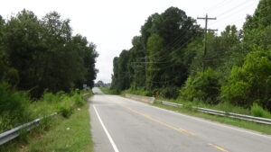
Walk between the creek and the pond by the parking lot. Stop near the highway where you can see across the bridge and down the road.
As the British army of Lt. Gen. Lord Charles Cornwallis moves from Wilmington to Virginia in 1781, local Patriots have gathered to oppose him at two stream crossings. A company of militia from the Franklin County Regiment, part-time soldiers under Capt. Harry Hill, wait on this side of Swift Creek. Their position is well chosen: Given the bend in the creek, and the angle of approach taken by the dirt wagon road where NC 4/48 runs now, a significant stretch of the route is within the 50 yards or so that muskets of the day can be effectively aimed.