
Location
Other maps: Bing, Google, MapQuest.
Coordinates: 35.2687, -83.2943.
Type: Stop
Tour: Cherokee
County: Jackson, Macon
![]() Full
Full
The coordinates place you on Victory Church Road off US 23/441. Drive past the church and its school to the kudzu-covered dead end.
The owner at the second stop, Gold City Gold Mine, has kindly agreed to let tour visitors use his parking lot. For some old-fashioned mining fun, souvenir stones, or beautiful jewelry, stop in.[1]


Description
The Original Road
 In retaliation for a series of attacks on settlements along the frontier by Cherokees pushed off their lands, Patriot militia commanders from the Carolinas and Virginia launched coordinated campaigns to destroy their villages. You are standing in the footsteps of the Cherokees who took warnings to the Middle Towns about the North Carolina army of Brig. Gen. Griffith Rutherford, seeing the forested peaks they would have seen. The road you are on was built on top of the ancient trading path over what now is called both Cowee and Watauga Gap.
A detachment of about 1,000 of Rutherford’s part-time soldiers, an advance force under Col. Francis Locke, passed this spot around 3 p.m. on Saturday, September 7, 1776. They were trying to reach the villages on the Little Tennessee River before residents could evacuate. Locke’s militia, riding or perhaps leading horses, made their way up the narrow trail here.
Defiance at the Gap
Drive back to US 23/441 and turn left. Climb to the top and on the other side of the gap, park at Gold City Gem Mine on the right.
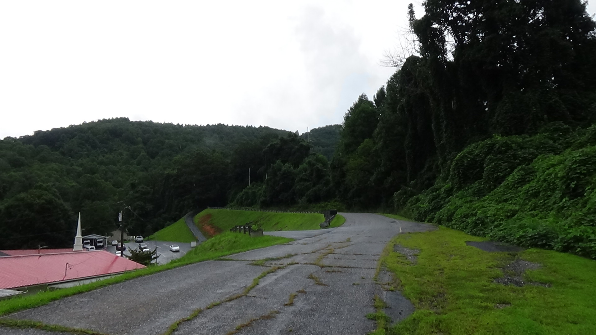
Look uphill at the gap. The cut for the modern highway dropped the gap below where this action took place, which was at the ground level toward the top of the “V” shape in the picture below.
The militia had spotted and followed some Cherokee men from the valley of the Tuckaseegee River on the other side of the mountain near modern Webster, so they were alert to the danger. About 20 warriors, perhaps those same men, awaited the soldiers on this side of the gap. When they got within 50 yards or less, the Cherokees rose up and fired a single musket volley at the column.

One man, Private Billy Alexander, fell to the ground with a cry of pain, clutching his foot.[2] The rest of the militia at the front spread out as best they could, preparing their guns. However, the warriors wisely disappeared into the woods to the right and down a smaller trail across Watauga Creek, in the ravine on the far side of the modern highway. The first of the militia soldiers clambered up to the gap, but arrived too late.

The militia paused long enough to bandage Alexander and put him on a litter; they had no wagons, so he may have made the rest of the trip that way.[3] They confiscated a few kettles from the Cherokees’ campsite and marched past you on the main trail.[4]
A day later the rest of Rutherford’s army, another 1,400 men, crosses the gap with hundreds of slow-moving packhorses and cattle wending up and down the steep, narrow trail.
After destroying dozens of villages, the army passed back in the other direction on Monday, September 30, riding between today’s Franklin and Webster.
For Those on the Trace
If you continue to the next stop on the Cherokee Campaigns Tour, you will be following the army’s route most of the way to Franklin, now called the “Rutherford Trace.” However, there is no direct modern route to its next campsite at Wata’gi (Watauga Town). The tour goes out of order from the march by visiting Nĭkwăsĭ´ first.
More Information
-
Dean, Nadia, A Demand of Blood: The Cherokee War of 1776 (Cherokee, N.C.: Valley River Press, 2012)
- Hamilton, J. G. de Roulhac, ‘Revolutionary Diary of William Lenoir’, The Journal of Southern History, 6.2 (1940), 247–59 <https://doi.org/10.2307/2191209>
- Lamar, Marshall, ‘The 1776 Campaign against the Cherokee’, The Smokey Mountain News, 2010 <https://www.smokymountainnews.com/archives/item/2173-the-1776-campaign-against-the-cherokee> [accessed 8 April 2020]
[1] Curt Rhoades, in-person interview, 8/25/2020.
[2] Lamar 2010.
[3] Ibid.
[4] In addition to the other listed sources, “Stop” information comes from one of two guidebooks; NCpedia; the online essay for the relevant North Carolina Highway Marker; and related Sight pages (see “About Sources”).
← Tuckaseegee | Cherokee Tour | Nĭkwăsĭ´ →