
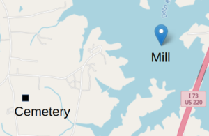
Location
Type: Hidden History
County: Randolph
Coordinates: 35.84, -79.8514
![]() Difficult
Difficult
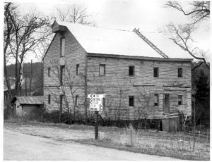
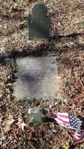
Martha Bell’s grave at the coordinates is surrounded by a privately owned farm field and can only be reached between fall harvest and spring planting. The remains of Bell’s Mill existed into the 21st Century, on Muddy Creek where it entered the Deep River. But it was flooded when the river was dammed to create Randleman Lake. Thus we consider the sites mostly “hidden.”
The cemetery is owned by a church, and can be driven to in winter, though getting to the grave requires walking over uneven and possibly muddy ground. Please respect the farm owners’ rights by not entering the field between plowing and harvest.

Description
A Successful Businesswoman
Unless otherwise footnoted, information in this section comes from a single source, a biography written by a direct descendant of Martha Bell based on good documentation.[1].
Martha MacFarlane was born in Virginia in 1735, and married North Carolina land speculator John McGee at 24.[2] McGee also owned a store, a mill, and an ordinary (food-serving tavern) near modern Julian, N.C., on the Great Trading Path from Petersburg, Va.
McGee was one of the sheriffs on the wrong side of the pre-Revolutionary protesters known as the “Regulators.” He may have used his position to pressure small landowners to take loans from him when they were unable to pay the taxes he was supposed to collect. When McGee died in 1773, 560 people owed him money, and he left an estate worth £7,769 ($1.2 million today).[3] Martha had him buried in a cornfield, against his wishes, probably to prevent his grave from being desecrated.
She ran the business for six years on her own, a “Gen. Gray” who knew Bell 10 years after the Revolution wrote Caruthers. When she needed more goods, having “‘incidentally learned from (McGee), during his life time, the names of all his lodging places on the road,’” she made supply runs to Petersburg. One time she got caught in a snowstorm on the way back, “‘but, having learned… that the largest and heaviest limbs of the pine tree are always on the south side, she took that for her guide; and without going much out of her way, she arrived at her… place of lodging.’”[a]
Martha likely met William Bell through business. She was 44 when she married him in 1779. Nothing is known of Bell’s early life. When they married, he owned 4,000 acres of land and the mill on the east side of the creek, which was 4,500 square feet and 15-feet tall. Before being flooded by Randleman Lake, part of the remaining foundation wall was still three feet thick! Bell was also a commissary officer, providing food supplies for Patriot (or “Whig”) forces. State “militia” soldiers were posted at the mill to guard it and escort supply trains for much of the war.
Martha also worked as a midwife, traveling alone on increasingly dangerous roads “well armed with dirk and pistols” when called. “‘She had a tender feeling for the sick and afflicted, administered to their wants, and, by her medical skill and attention, relieved many without fee or reward,’” Gray wrote. Accosted once by an infamous Loyalist (“Tory”), she took him prisoner and marched him home, though he escaped later.
The Bells found themselves in a new county, Randolph, the year they were married. Bell was named one of the first magistrates, a combination judge and county commissioner, and sheriff. The Bell home, on a hill across the creek from the mill, served as the second courthouse for the county.
Just prior to the British invasion of North Carolina now called the “Race to the Dan,” a Whig colonel wrote the southern Continental commander Maj. Gen. Nathanael Greene that 4,000 pounds of salted beef, plus large amounts of flour and horse feed, were stored at the mill. During the Race, Greene’s main army picked up these supplies on its way from South Carolina, as it headed to Guilford Court House (in modern Greensboro) to meet up with the rest of the army and Greene himself.
British Encounters
Most modern sources refer to a single 1850s source that provides most of the information and the quotes on this page.[4] Rev. Eli Caruthers interviewed multiple witnesses, read available documents, and did not appear to make up stories like some of his contemporaries. Modern historians have been able to corroborate basic facts about Bell from other original documents. Still, believe details with caution!
The British stopped at the mill weeks later while hunting the Continentals, after Greene had crossed the Dan River to Virginia and then returned to N.C. Finding no provisions, they moved on the next day.[5] But their visit exposed the man who ran the mill for the Bells as a secret Loyalist, because he welcomed the British. Martha fired him.
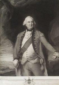
After the Battle of Guilford Court House in today’s Greensboro, the British Army remained on the battlefield a few nights before its commander, Lt. Gen. Lord Charles Cornwallis, decided to move south to recover. On March 18, 1781, the army camped on the Bell’s Mill property and the plantation immediately north of it.
William made himself scarce to avoid capture. Three children, from 13 to 20, were living at home, along with some number of enslaved people.[6] Cornwallis told Martha he was going to use the mill to grind grain for the troops and would occupy her house. She asked if he was going to burn them. Cornwallis said no, and asked why she had asked. Bell supposedly replied that if he “‘intended to burn our mill, I had intended to save you the trouble by burning it myself before you derived much benefit from it…’”
She told several neighbors afterward that Cornwallis first claimed he had wiped out the Continental army. But he kept opening the back door that looked onto the road to Cross Creek (now Fayetteville). When she asked why, he admitted, “‘Well, madam, to tell you the truth, I never saw such fighting since God made me, and another such victory would annihilate me.’”
During the encampment:
- A British officer insulted her while passing the house to water his horse. She yelled back that she hoped it threw him and broke his neck. Because he was riding recklessly, a few minutes later it did! As viewed in 2001 before the lake covered it, the hillside from the house to the creek featured a sharp drop leading to a roughly 40-degree slope with large rocks, evidence this story could be true.[7]
- Bell hid her money under a large rock that served as the bottom step to her door when the army first approached, thinking the camp would be further off, and the soldiers wouldn’t look there. When they camped at the mill instead, she wandered the area one day, asking generic questions and inspecting tents, until the soldiers became disinterested in her. On the way back inside, she safely grabbed her money.
- When Cornwallis was absent, some soldiers came into the house demanding the cider she kept in the basement. She stood her ground and made them leave.
- A family tradition claims Cornwallis and his officers planned their retreat with maps spread on the dining table, so Martha was able to learn their plans and pass those to Patriots.[8]
After two days the army marched east toward Dixon’s Mill at Snow Camp, taking with it all of the Bells’ grain, bacon, cattle, and other provisions—but not her cider! Continental Lt. Col. Henry Lee showed up shortly afterward. Whether he asked her to do this, or she volunteered, is unknown, but Bell mounted up and went to the new British camp. She complained to Cornwallis about damage she only learned about after they left. In fact, she was spying, and returned to Lee with what she had learned.
Sparring with Tories
Sometime later a Whig scout approached her, saying he had heard of a Tory militia force forming nearby. Bell went with him to try to find it. In the guise of a midwife afraid of being attacked, she asked questions of everyone they met as to the Tories’ whereabouts until the pair succeeded. They had ridden 30 miles when they got back. The scout informed Lee, who broke up the encampment.
At some point when her Patriot father was visiting, two Loyalists broke in intending to kill him. Her pistols were not handy, so she grabbed an axe and held it over her head. Caruthers reports that she said, “‘If one of you touches him, I’ll split you down with this axe.’” They wisely backed off.
That autumn, Loyalists learned William was back home from a trip north. They approached the house, wounded him when he stuck his head out the window to investigate, and prepared to burn the place. Martha yelled outside to their enslaved servant, Pete: “‘Run as hard as you can to Jo Clarke’s and tell him and the light-horse to come as quickly as possible, for the Tories are here.’” Clarke was a cavalry militia officer who lived a mile away. Again the Tories decided to leave.
Finally, infamous Tory Col. David Fanning showed up at the house with 25 mounted men in home-made uniforms the night he had murdered Patriot Col. Andrew Balfour near today’s Asheboro. By this time, eight to 10 Patriots from the area regularly stayed at the house for Martha’s protection when William was in hiding. She called to them—loudly enough to be heard outside—to open the windows, but not to fire until they had a sure aim on someone. Even David Fanning thought better of challenging Martha Bell, and he moved on.
Historical Tidbit
After the war, William returned to the family business and was elected to the state legislature. Marth died peacefully at 85, in 1820. When William died four years later, his will kept a promise to a friend, Thomas Lytle. Lytle left legal rights to his enslaved people to Bell, asking Bell to free them and give them Lytle’s land. In his will, Bell did so and appointed trustees to ensure the people got the property. However, Bell only freed one of his own slaves, Susannah, who was old. He did provide for her care. Bell lies by Martha, his grave unmarked.[9]
More Information
- Associated Press, ‘DAR Office Questions Martha Bell Heroics’, The Courier-Tribune (Asheboro, N.C., 3 April 1997)
- Caruthers, E. W. (Eli Washington), Interesting Revolutionary Incidents and Sketches of Character, Chiefly in the ‘Old North State.’ (Philadelphia : Hayes & Zell, 1856) <http://archive.org/details/interestingrevol00incaru> [accessed 23 April 2020]
- Lehman, Sarah, tran., ‘Isaac Farlow’s Statement of Revolutionary Events’, North Randolph Historical Society Quarterly, II.III (1968)
- ‘Martha Bell – History of American Women’ <http://www.womenhistoryblog.com/2010/12/martha-mcfarland-mcgee-bell.html> [accessed 23 April 2020]
- Schlosser, Jim, ‘DAR Decides Bell Is a Patriot After All’, Greensboro News and Record, 18 June 1997
- Suggs, Joseph, ‘Bell, Martha McFarlane McGee’, Randolph County Public Library—Randolph Room, Vertical Files
- Wellborn, Jennifer, Martha MacFarlane McGee Bell: Heroine, Patriot, and Spy, and the Case for Caruthers (Rock Hill, S.C.: Self-published, 2002)
[1] Wellborn 2022.
[2] According to Wellborn, some sources mistakenly say she was born in Orange County, N.C., but it was the Virginia county by that name.
[3] Nye, Eric, ‘Currency Converter, Pounds Sterling to Dollars, 1264 to Present’ <https://www.uwyo.edu/numimage/currency.htm>.
[4] Caruthers 1856.
[5] Wellborn.
[6] Ibid.
[7] Ibid.
[8] Ibid.
[9] Wellborn, which includes a transcription of the will.
[a] Quoted in Caruthers.